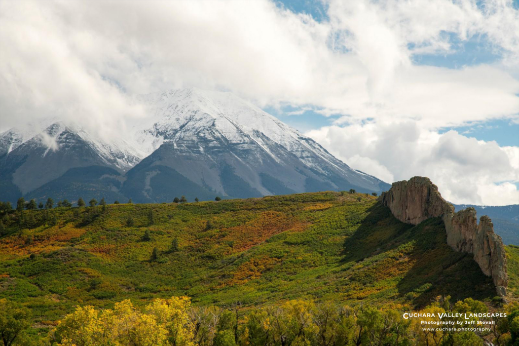
She rises above the Cuchara Valley with a presence that refuses to be overlooked. In Pinehaven, she fills your windows, commands your view, and quietly shapes your sense of place. Known as West Peak, one half of the iconic Spanish Peaks, she is both familiar and mysterious. Yet for all her prominence, many who live in her shadow know surprisingly little about the mountain that defines their horizon. And the more you look at West Peak, the more you realize how much of its story is hidden in plain sight.
Sisters Not Twins
They stand side by side, but West and East Peak could not be more different. From a distance they appear similar, but in geology, history, and even the role they play in the landscape, they diverge sharply. West Peak is shaped like a volcano, even though it is not. It rises steeply, rugged, and rocky all the way to the top. East Peak, by contrast, is broader, smoother, and more heavily forested. If West Peak is a spire, East Peak is a dome. One looks like it’s reaching for the sky; the other looks like it’s settled in for the long haul.
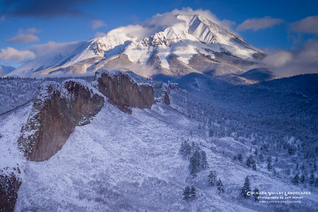
Elevation reinforces that contrast. West Peak rises to 13,583 feet with a cone-shaped form and an exposed, rocky summit that makes for a more difficult climb. East Peak, at 12,688 feet, has a wider, rounded summit and gentler slopes, making it easier to explore. West Peak feels alpine and dramatic; East Peak, accessible and expansive.
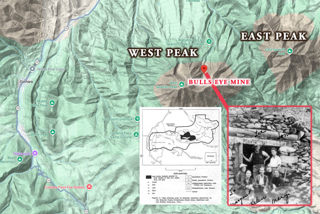
Though they share a similar origin, the two peaks tell very different geological stories. West Peak formed when molten rock rose beneath the surface, hardened, and was later uncovered as the land above wore away. It contains mineral veins and small mines, including the Bulls Eye, along with long rock walls called dikes that radiate outward like spokes on a wheel. These dikes formed when magma filled underground fractures and cooled into solid rock. East Peak formed through the same general process, but shows far less of this activity with fewer visible signs of mineralization.
West Peak transitions quickly from dense forest to steep, broken terrain, while East Peak features more open slopes, meadows, and gradual transitions.
West Peak projects energy, height, and intensity, while East Peak feels steady, calm, and expansive. One draws your attention. The other completes the scene.
Above Everything
She doesn’t just rise above the valley; she quietly dominates everything around her. Rising to 13,583 feet, West Peak is located in the Spanish Peaks Wilderness of San Isabel National Forest near the Culebra Range.(1) The mountain straddles the county line with its summit in Las Animas County, Colorado.(2) It ranks twelfth in topographic prominence in Colorado.(3)
The Peak that Never Blew
West Peak looks like a volcano, but its story is far stranger. It formed when molten rock rose beneath the surface but never erupted. Over millions of years, the land above it wore away, revealing the mountain we see today.
It did all the work of becoming a volcano, and then stopped just short of the part most people remember.

Long rock walls called dikes spread out from the peak like spokes on a wheel. These formed when pressure fractured the surrounding rock, allowing magma to fill the cracks and harden into stone. Over time, erosion stripped away the softer layers above, leaving the dikes exposed. That’s why today the dikes stand above the ground like walls, even though they formed below the surface.(4)
Geologists estimate that more than 500 dikes radiate outward from West Spanish Peak, forming one of the most extensive radial dike systems in North America.(5)
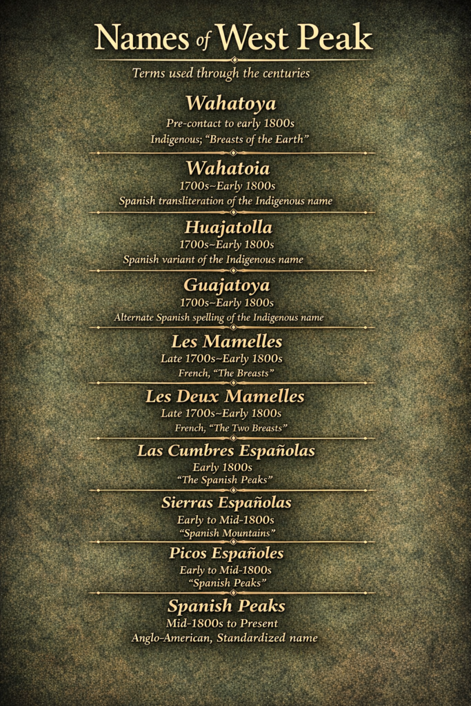
A Mountain of Many Names
How did West Peak get its name? The answer is not a single moment in time, but a story that unfolds layer by layer through maps, sketches, and official records.
Long before any written record, Indigenous peoples lived in and moved through the region. The name “Wahatoya,” sometimes translated as “breasts of the earth,” is often attributed in local tradition to the Ute. However, research indicates the term is more accurately derived from the Comanche language, meaning “double mountain” and reflecting their twin form.(6)
 The Arapaho and Cheyenne hunted on the eastern plains, and the Apache south near the New Mexico border. Though they used the peaks for reference and navigation, no record of their names remains.
The name “Las Cumbres Españolas” (Spanish Peaks) likely emerged during the Spanish colonial period. In 1821, a traveler named Jacob Fowler was on his way to Taos, New Mexico when he recorded in his journal that his party reached “Las Cumbres Españolas” or “Spanish Peaks”. The peaks were known by the French as “Les Tetons” or “Les Mamelles,” meaning “The Breasts”.(7). By 1853, the name “Spanish Peaks” appeared on a drawing of the mountains, confirming it was already in common use.(8)
By 1901, the naming of the region became more formalized through the work of the United States Geological Survey.(9) Their Spanish Peaks folio established a clear and authoritative framework for mapping the area, placing most of the region in Las Animas County with a smaller portion in Huerfano County.(10)
The Spanish Peaks are a classic example of toponymic layering, a place where each passing culture left its own name behind. A list of various names that have been used over time can be found in the footnotes.(11) None of those names are wrong. Each one is simply a snapshot of how that culture saw the mountain at the moment they encountered it. In a sense, the Spanish Peaks have been “renamed” more times than a small-town diner under new ownership.
Before Pinehaven
Long before cabins, roads, or even maps, people were already watching this mountain. West Spanish Peak served as a visual landmark for Indigenous peoples and explorers long before it was associated with the Cuchara we know today. West Peak was known to the Ute people, Comanche, and Apache. To those who moved across the plains and into the mountains, the twin summits were more than scenery.
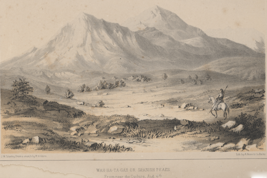
One of the earliest pictures of the Spanish Peaks comes from the 1853 Gunnison expedition. Members of the Pacific Railroad Surveys moved through the region, documenting what they saw. A Smithsonian lithograph based on drawings by Richard H. Kern and John Mix Stanley preserved their work. It shows the peaks being recorded in the mid-1800s, when the name “Wah-Ha-Ta-Gas” was already in use.(12) “Wah-Ha-Ta-Gas” is a historic, phonetic Native name for the Spanish Peaks, preserved in expedition records, though its exact translation is no longer known.(13) Drawn in 1853 and published as a lithograph in 1855, the image likely depicts a westward view from near Cuchara, with West Spanish Peak as the dominant feature.
West Spanish Peak has remained what she has always been, a landmark shaped by deep time, known first by Indigenous peoples, recorded by explorers, tested by settlers, and ultimately preserved. A mountain that does not demand attention, but quietly keeps it once seen.
The Peak That Wouldn’t Pay
For a time, people believed West Peak might make them rich, but the mountain had other plans. Mining played a role in West Peak’s history in the early 20th century. Because of easier access and small mineral veins, the east side proved more productive, though only modest placer gold was recovered as early as 1901.(14) Monarch Basin produced ore containing silver, lead, gold, copper, and zinc, but only in limited amounts from small vertical veins.(15) The Bulls Eye Mine on the east side of West Spanish Peak remained the most prominent source in the early years.(16) The west side facing Cuchara proved less valuable and difficult to access due to rough terrain.
Before 1900, mining consisted primarily of prospecting along tributaries.(17) From the late 1800s to 1908, activity peaked, focusing on silver and lead-bearing quartz with associated copper, zinc, and minor gold. After 1908, mining declined, with the last documented production in the 1930s and full cessation by 1982.(18) Even today, minerals remain, but not in quantities sufficient to make mining worthwhile.(19)
The Inviting Forest
By the early 1900s, the Cuchara Valley side of West Spanish Peak told a different story than the untouched wilderness many imagine. The forests surrounding the peak were not just scenic, they were working landscapes. Loggers cut timber for railroad ties, mine supports, and building materials that fed a growing region.(20)
Long before formal maps and forest boundaries, Hispanic families used these lands for seasonal grazing and small settlements, a pattern that continued as new homesteaders arrived in the late nineteenth century.(21) This was not empty land waiting to be discovered. It was land already known, used, and depended upon.
When the federal government established the San Isabel National Forest in 1902, it wasn’t setting aside a pristine wilderness. It was stepping into a landscape already shaped by grazing, timber use, and settlement, and beginning to manage it.(22)
By 1919, the Forest Service was no longer thinking only about resources. It was planning for recreation, mapping camps, roads, and public use in places like the Spanish Peaks.(23) What had been a place of work was becoming a place to visit and explore.
By around 1910, the land around West Spanish Peak had already been shaped in multiple ways, trees cut, families settled, and visitors beginning to arrive. The mountain still stood wild and commanding, but the valley below it was already becoming something more familiar, a lived-in landscape shaped by both necessity and discovery.
Where Water Begins
Long before its streams ever reach a valley, West Spanish Peak is already at work, capturing, storing, and releasing water that sustains everything below. Rising to over 13,000 feet, the mountain intercepts moisture from passing weather systems, accumulating snowpack that functions as a natural reservoir, holding snow in winter and releasing it during spring melt.(24) From its slopes, water flows downward to creeks such as Wahatoya, Trujillo, Chaparral, and Echo, forming the headwaters of multiple drainage systems.(25) These waters flow into larger basins, including the Apishapa River, which carries runoff east to the Arkansas River. Positioned near a natural drainage divide, West Spanish Peak does not simply collect water, it distributes it across the landscape, sustaining ecosystems, agriculture, and communities far beyond its base.(26)
Wilderness Gone Wild
What looks like a quiet mountain is actually one of the busiest ecosystems in the region. West Spanish Peak does more than frame the skyline above the Cuchara Valley, it helps sustain the life within it. As snow builds on the mountain and melts each spring, runoff feeds creeks and soils below, a process common in Colorado watersheds where snowpack supplies much of the downstream water and habitat.(27) This flow waters the grasses and plant life that form the base of the valley’s wildlife system.
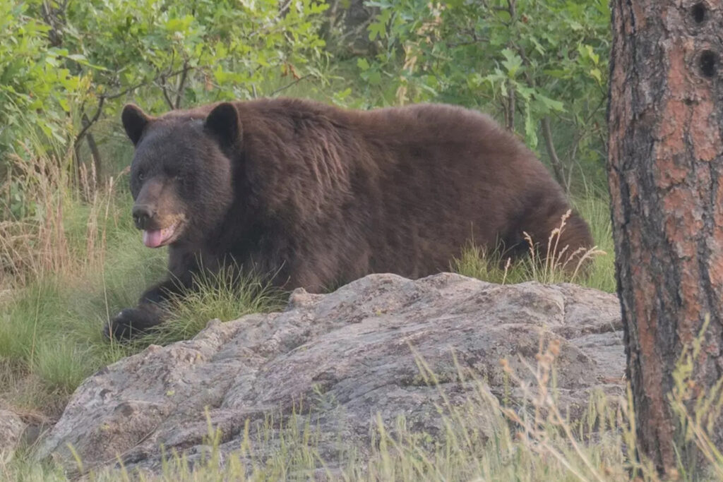
West Peak is identified by state wildlife managers as essential habitat for multiple species, including elk, mule deer, wild turkey, black bear, mountain lion, bighorn sheep, and golden eagle. Scientific field studies conducted directly within the Spanish Peaks State Wildlife Area have also documented a wide variety of smaller mammals, including species such as deer mouse, rock mouse, and Abert’s squirrel, showing the ecosystem supports wildlife at multiple levels.(28)
This is not a landscape defined by a single species, but a concentrated, high-functioning habitat system where large game, predators, birds, and small mammals all overlap in a relatively compact mountain environment centered on West Spanish Peak.
Shaping Weather
West Spanish Peak does not just shape the skyline, it quietly shapes the weather as well. Rising abruptly from the edge of the plains near the Sangre de Cristo Mountains, the mountain acts like a natural barrier that forces air upward, producing clouds, rain, or snow on one side while leaving drier conditions on the other.(29)
In the summer, it helps spark afternoon thunderstorms as warm air rises over the peak and builds into towering clouds that later drift into nearby valleys. This helps keep Pinehaven green and lush. At night, a different pattern emerges. Cooler air drains off the slopes and settles into low places like the Cuchara Valley, creating pockets of colder temperatures while slightly higher areas like Pinehaven can remain warmer.
The result is a landscape where weather can change over surprisingly short distances, because the mountain itself is quietly directing the flow of air, moisture, and temperature around it.
West Spanish Peak does not just stand above the valley, it shapes it in water, in weather, in history, and in memory. What seems familiar at a glance reveals itself, over time, as something far deeper. A mountain that has always been there, and yet is never fully known.(30)
* Want to bring the beauty of Cuchara into your home or cabin? Discover Jeff Stovall’s stunning photography at www.cuchara.photography.
Footnotes
Parenthetical numbers in the text (e.g., 5) correspond to the sequentially numbered citations listed below.
1. West Spanish Peak, though administratively managed as part of the Pike-San Isabel National Forest alongside the Culebra Range of the Sangre de Cristo Mountains, is geologically distinct from that range — an igneous stock emplaced approximately 24 million years ago, separated from the Culebra Range to the west by the Cuchara Valley.
2. U.S. Geological Survey, Geographic Names Information System (GNIS), “West Spanish Peak”, accessed April 13, 2026, https://edits.nationalmap.gov/apps/gaz-domestic/public/search/names/194402.
3. John Kirk, “West Spanish Peak – 13,584′ Colorado,” ListsOfJohn, noting West Spanish Peak’s Colorado prominence rank as 12 (“CO Prominence Rank: 12”), accessed April 13, 2026, https://listsofjohn.com/peak/222. Note: West Spanish Peak is sometimes listed at 13,583 feet and other times at 13,584 feet. The difference comes from how the height was measured. Older surveys used tools and math from the ground to estimate elevation, which gave a very close number. Newer technology called LiDAR uses lasers from airplanes to measure the ground much more precisely. In simple terms, the older method gives a close estimate, while the newer laser method gives a more exact measurement, which is why the numbers can differ by about one foot.
4. U.S. Geological Survey and U.S. Bureau of Mines, Mineral Resources of the Spanish Peaks Wilderness Study Area, Huerfano and Las Animas Counties, Colorado (1983), describing a radial swarm of dikes formed by stresses around the West Spanish Peak intrusion.
5. B. S. Penn, “⁴⁰Ar/³⁹Ar Dates for the Spanish Peaks Intrusions in South-Central Colorado,” Rocky Mountain Geology 44, no. 1 (2009): 17–34, https://pubs.geoscienceworld.org/uwyo/rmg/article/44/1/17/141039/40Ar-39Ar-dates-for-the-Spanish-Peaks-intrusions
6. National Park Service, “The Spanish Peaks: Land of Legend and Lore,” National Park Service History eLibrary, noting that the name “Wahatoya” is not Ute or Apache but Comanche in origin, https://npshistory.com/publications/grsa/dwr-v76n5-2020.pdf.
7. The World Journal, “Miss Spelling Had Many Friends,” accessed April 14, 2026, https://worldjournalnewspaper.com/miss-spelling-had-many-friends/. For comparison with better-documented Indigenous naming traditions, see “Spanish Peaks,” which notes the related name “Huajatolla” (Comanche) meaning “double mountain,” Wikipedia, accessed April 14, 2026, https://en.wikipedia.org/wiki/Spanish_Peaks.
8. A. Hoen & Company, Wah-Ha-Ta-Gas or Spanish Peaks from Near Cuchara Aug 6th, tinted lithograph, ca. 1853, Smithsonian Institution, National Museum of American History, https://americanhistory.si.edu/collections/object/nmah_785453
9. The United States Geological Survey published the Spanish Peaks Folio in 1901 as part of its Geologic Atlas of the United States. This document uses the name “Spanish Peaks” as the official title and applies the name consistently across maps and descriptions which established it within a formal federal mapping framework. Also see Richard C. Hills, Spanish Peaks Folio, Colorado, Folios of the Geologic Atlas of the United States No. 71 (Washington, DC: United States Geological Survey, 1901), https://doi.org/10.3133/gf71
10. National Park Service, “Spanish Peaks National Natural Landmark,” describing the designation of the Spanish Peaks within the San Isabel National Forest, managed by the United States Forest Service, https://www.nps.gov/subjects/nnlandmarks/site.htm?Site=SPPE-CO
11. Across languages and centuries, the Spanish Peaks have been named again and again, not because they changed, but because each culture saw them through its own lens. This is called toponymic layering. The following names associated with the Spanish Peaks reflect different cultural periods of use. The date ranges are approximate and based on historical context, not precise points of origin, but rather when each name was most commonly in use.
- Wahatoya — Indigenous (Ute/Apache-associated); commonly translated “Breasts of the Earth” (Pre-contact to early 1800s)
- Wahatoia — Spanish transliteration of the Indigenous name (1700s–early 1800s)
- Huajatolla — Spanish transliteration variant of the Indigenous name (1700s–early 1800s)
- Guajatoya — Spanish transliteration variant of the Indigenous name (1700s–early 1800s)
- Les Mamelles — French trappers; “The Breasts” (late 1700s–early 1800s)
- Les Deux Mamelles — French variant; “The Two Breasts” (late 1700s–early 1800s)
- Las Cumbres Españolas — Spanish/Mexican usage; “The Spanish Peaks” (recorded by Jacob Fowler, 1821) (early 1800s)
- Sierras Españolas — Spanish variant; “Spanish Mountains” (early to mid-1800s)
- Picos Españoles — Spanish variant; “Spanish Peaks” (early to mid-1800s)
- Spanish Peaks — Anglo-American; standardized modern name (mid-1800s to present)
Yet remarkably, many of these names, across different languages and cultures, arrived at the same conclusion. Long before maps agreed on a name, the mountains had already told people what they looked like.
12. A. Hoen & Company, Wah-Ha-Ta-Gas or Spanish Peaks from Near Cuchara Aug 6th, tinted lithograph, ca. 1853, Smithsonian Institution, National Museum of American History, https://americanhistory.si.edu/collections/object/nmah_785453
13. A mid-19th-century account associated with the 1853 Gunnison expedition records the term “Wah-ha-ta-gas” as a name applied to the Spanish Peaks; see The World Journal, “Miss Spelling Had Many Friends,” accessed April 14, 2026, https://worldjournalnewspaper.com/miss-spelling-had-many-friends/. For comparison with better-documented Indigenous naming traditions, see “Spanish Peaks,” which notes the related name “Huajatolla” (Comanche) meaning “double mountain,” Wikipedia, accessed April 14, 2026, https://en.wikipedia.org/wiki/Spanish_Peaks.
14. R. C. Hills, Description of the Spanish Peaks Quadrangle (U.S. Geological Survey Folios of the Geologic Atlas, Folio 71, 1901), text PDF, https://pubs.usgs.gov/gf/071/text.pdf.
15. R. C. Hills, Description of the Spanish Peaks Quadrangle (U.S. Geological Survey Folios of the Geologic Atlas, Folio 71, 1901), text PDF, https://pubs.usgs.gov/gf/071/text.pdf.
16. Bull’s Eye Mine, near West Spanish Peak, Huerfano County, Colorado, approximately 37.38333, -104.97833, Google Maps, accessed April 14, 2026, https://www.google.com/maps?q=37.38333,-104.97833. Coordinates are based on U.S. Geological Survey mineral resource data and indicate the general location of the historic mine, likely within several hundred feet of the actual workings rather than a precisely surveyed site.
17. John W. Vanderwilt, Mineral Resources of Colorado (Denver: Colorado Mineral Resources Board, 1947), as cited in Western Mining History, “Huerfano County Mining Districts,” https://westernmininghistory.com/library/38254/page1
18. Karin E. Budding and Steven E. Kluender, Mineral Resource Potential of the Spanish Peaks Wilderness Study Area, Huerfano and Las Animas Counties, Colorado, U.S. Geological Survey Miscellaneous Field Studies Map MF-1542-C (Washington, DC: U.S. Geological Survey, 1983), https://pubs.usgs.gov/mf/1542-C/report.pdf. The report documents that a small amount of placer gold was produced in 1932 and 1934 and that four tons of lead-silver ore were shipped in 1934–1935; it further states that no active mining or exploration was underway during the 1982 field investigation, establishing that mining had ceased prior to that date.
19. Karin E. Budding and Steven E. Kluender, Mineral Resource Potential of the Spanish Peaks Wilderness Study Area, Huerfano and Las Animas Counties, Colorado, U.S. Geological Survey Miscellaneous Field Studies Map MF-1542-C (Washington, DC: U.S. Geological Survey, 1983), https://pubs.usgs.gov/mf/1542-C/report.pdf
20. Eric Twitty, A Brief Study of the Lumber Industry in Colorado, 1858–1948 (Denver Public Library), documenting widespread timber harvesting for railroad ties and construction in Colorado’s mountain regions. He also references Dolores Renze’s work as well. https://www.codot.gov/projects/i70mountaincss/assets/docs/pdfs/corridor-team-meetings/october-10-2008/october-2008-historic-context/research-logging.pdf
21. Minette C. Church et al., Historic Hispanic Settlement and Land-Use on the Pike and San Isabel National Forests and the Comanche and Cimarron Grasslands, documenting long-standing Hispanic seasonal land use, grazing, and settlement patterns in southern Colorado. https://www.academia.edu/445664
22. U.S. Forest Service, San Isabel Forest Reserve and National Forest, Colorado (1902–Present), noting that the forest reserve incorporated lands already used for grazing, timber, and settlement at the time of its establishment. https://nfsl.contentdm.oclc.org/digital/api/collection/p17053coll4/id/1307/download
23. W. T. Cermak, General Working Plan for Recreation Development of the San Isabel National Forest (1919), outlining early federal plans for camps, roads, and recreational development in areas including the Spanish Peaks. https://foresthistory.org/wp-content/uploads/2017/01/Cermak_Plans.pdf
24. U.S. Geological Survey, “How Changing Snowmelt Affects Water in the Western United States,” USGS Water Science School, accessed April 14, 2026, https://www.usgs.gov/water-science-school/how-changing-snowmelt-affects-water-western-us.
25. U.S. Geological Survey and U.S. Bureau of Mines, Mineral Resource Potential of the Spanish Peaks Wilderness Study Area, Huerfano and Las Animas Counties, Colorado, U.S. Geological Survey Miscellaneous Field Studies Map MF-1542-C (Washington, DC: U.S. Geological Survey, 1983), https://pubs.usgs.gov/mf/1542-C/report.pdf
26. U.S. Geological Survey, “Apishapa River,” National Hydrography Dataset summary, https://waterdata.usgs.gov.
(Confirms the Apishapa River as a drainage receiving headwaters from the Spanish Peaks region and flowing to the Arkansas River.)
27. Water Education Colorado, “Watershed Health & Forest Health,” explaining how mountain snowpack contributes to downstream water, soil moisture, and ecosystem support. https://watereducationcolorado.org/water-101/hydrology-water-resources/watershed-health-forest-health/
28. Ron S. Mellott, Jerry R. Choate, and Charles Loeffler, “Mammals of the Spanish Peaks State Wildlife Area, Colorado,” Fort Hays Studies, documenting numerous small mammal species within the Spanish Peaks region.
https://scholars.fhsu.edu/fort_hays_studies_series/68/
29. National Weather Service, “Orographic Lifting,” accessed April 14, 2026, https://forecast.weather.gov/glossary.php?word=OROGRAPHIC; American Meteorological Society, “Rain Shadow,” Glossary of Meteorology, https://glossary.ametsoc.org/wiki/rain-shadow/; Christopher Daly and Kirk Bryant, The PRISM Climate and Weather System—An Introduction (Oregon State University, 2013), https://prismstage.nacse.org/documents/PRISM_history.pdf.
30. Author’s note: In preparing this article, the author used AI-assisted tools for research support, proofreading, fact-checking, and stylistic refinement. All narrative choices, analysis, and historical interpretations are the author’s own, and responsibility for accuracy rests solely with the author. The blog’s research methodology statement is available at https://cabininthepinescuchara.blogspot.com/2019/03/methodology-sources-and-use-of-research.html
One Response
How great for you to share this for free! I lived for a while in La Veta and in Cuchara. I’m looking forward to reading this when I have the time! Thank you!!!