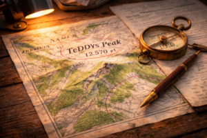
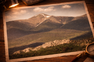
 Rising above the timbered folds of the Cuchara Valley, Teddys Peak stands as one of southern Colorado’s most recognizable high-country landmarks.(1) Located within the San Isabel National Forest, the summit straddles Huerfano and Costilla Counties, reaching approximately 12,570 feet.(2) It anchors the skyline and catches both the first light of sunrise and the last glow of evening.
More than a topographic feature, Teddys Peak serves as a constant point of reference for residents and visitors alike. It shapes the valley’s weather, feeds its watershed, and defines its recreational identity. In many ways, it is not just a mountain above Cuchara, but a presence that helps define the valley itself.
Yet one question remains: who was “Teddy”?
The American West is filled with place names whose origins have faded into obscurity, some formally assigned and others born from local habit and memory. Teddys Peak appears to fall into this latter category.
This article examines the leading theories behind its name and evaluates the evidence pointing to the most plausible conclusion: that the peak was named in honor of Theodore Roosevelt.
Why This Question Persists
 Teddys Peak is recorded in the Geographic Names Information System (GNIS) as “Teddys Peak” (Feature ID 192934) and is located in Costilla County.(3) Although the name appears on official maps and is recognized in federal records, no single archival document has yet surfaced confirming that the mountain was named in honor of Theodore Roosevelt. No alternative names are recorded, though several theories have been proposed.
Possible Origins of the Name
How the name “Teddy” became attached to the peak has inspired several compelling theories.
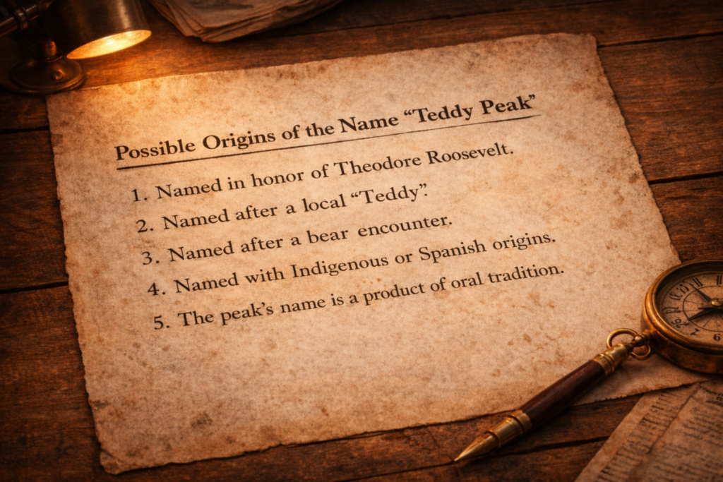
The peak was named in honor of Theodore Roosevelt. This interpretation holds that Teddy Roosevelt’s conservation policies directly shaped the landscape in which it stands. The area now known as the San Isabel National Forest was first placed under federal protection on April 11, 1902, then enlarged in 1905 and 1906 during Roosevelt’s presidency.(4) Roosevelt’s controversial 1907 “Midnight Forest” proclamations created a new forest reserve called the Las Animas National Forest reserve, which included what we know now as Teddys Peak.(5) Later in 1910, the Las Animas National Forest, along with Teddys Peak was consolidated into the San Isabel National Forest.(6)
Issued under the authority of the Forest Reserve Act of 1891, this action tied Roosevelt’s name to the preservation of the region.(7) Within this context, the evidence supports the interpretation that a prominent summit within that protected landscape could have been named in recognition of the president responsible for its conservation and expansion.
The peak was named after a local “Teddy.” This theory proposes that “Teddys Peak” may have been named after a local individual named “Teddy,” rather than Theodore Roosevelt. It reflects the common practice of informal local names later being adopted into official maps, especially in regions shaped by place naming traditions.
Arvid D. Blecha’s Colorado Place Names: A Genealogical and Historical Guide, is one of the most comprehensive compilations of Colorado place-name origins.(8) A review of the manuscript yielded no entry for Teddys Peak. This absence weakens the likelihood of a documented local namesake and suggests no widely recognized local, Spanish, or Indigenous naming tradition was preserved. While not conclusive, the theory remains unproven unless a specific local “Teddy” can be identified in historical records directly connected to the peak.
The peak was named after a bear encounter. This theory suggests the name may have originated from a local animal story, possibly tied to the “teddy bear” nickname and consistent with nearby wildlife-themed place names such as Bear Lake. While this type of naming was not uncommon in the region, no documentary evidence supports the claim.
The peak’s name may have Indigenous or Spanish origins. The area surrounding the peak reflects a layered naming history, with many place names derived from Spanish and Indigenous traditions. However, no evidence has been found that this specific mountain ever held a name within those traditions. The word “Teddy” is distinctly English, commonly used as a nickname for Theodore, Ted, or Theo, and does not derive from Spanish or Indigenous languages in the region. Its presence therefore points to the period of Anglo-American settlement that expanded into the Sangre de Cristo region in the late nineteenth century, when informal local naming practices often became formalized on maps. This same period also supports the likelihood of an honorific name associated with a nationally recognized public figure.(9)
The peak’s name is a product of oral tradition. It likely emerged through long-standing local use before appearing on maps. Many iconic American place names began this way, arising from everyday usage before later being formalized in official maps.(10)
The Case for Theodore Roosevelt
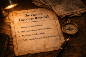 More than a century ago, a president who believed forests should be protected rather than exploited reshaped the American landscape through policy, persuasion, charisma, and personal conviction. The ripple of those decisions reached deep into the high country above Cuchara. The name Teddys Peak most likely reflects Theodore Roosevelt’s legacy.
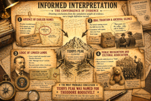
No single archival record confirms the name’s origin; instead, the conclusion rests on informed interpretation drawn from a convergence of evidence. The following four lines of evidence support that conclusion.
Absence of earlier names. There is no record of the mountain bearing any earlier name prior to its appearance as ‘Teddys Peak’ on a 1942 San Isabel National Forest map and a 1954 U.S. Army Corps of Engineers Map.(11) The designation of Teddys Peak on an Army Service product map and a San Isabel National Forest map indicates that the maps were compiled by federal agencies using existing surveys, aerial photography, and established geographic names, rather than creating a new name. Its inclusion of “Teddys Peak” therefore reflects that the name was already in established local and federal use by the early 1940s and incorporated into official mapping for navigation and planning purposes.(12) Maps are not merely passive records of geography; they are evidence of accepted naming, preserving the names that were already in common or administrative use at the time they were created.
 The name appears without an apostrophe and without a naming citation, biographical note, or listed variant in the Geographic Names Information System (GNIS) or associated mapping documents.
Many locals instinctively write the name as “Teddy’s Peak,” assuming a possessive form. Federal usage does not. Since 1890, the U.S. Board on Geographic Names has discouraged the possessive apostrophe in domestic geographic names, allowing only a handful of rare exceptions.(13) This long-standing policy explains why the official GNIS record lists the summit as “Teddys Peak.” The spelling reflects federal naming convention rather than a statement about who “Teddy” was or why the name was chosen.
Roosevelt had died just twenty-three years earlier, in 1919.(14) The appearance of “Teddys Peak” on a map as early as 1942 places the name well within living memory of his presidency, when his conservation legacy remained both visible and widely discussed across the region. This proximity strengthens the likelihood that the name reflects a cultural association rather than a later, disconnected attribution.
Prior to his death, no known federal map or information system identifies the mountain by another designation.(15) Both the 1942 and 1954 map appearances place the name within the generation that institutionalized Roosevelt’s conservation legacy in Colorado.
Oral tradition and archival silence. The U.S. Board on Geographic Names (BGN) has a Domestic Names Committee that standardizes the names of geographic features in the United States. It reviews naming proposals and relies on historical evidence, local usage, and government input to guide its decisions.(16) However, not all geographic names are reviewed by the Board, and BGN records often do not document the origin of a name.
Historical studies of U.S. Forest Service mapping show that official maps often preserve accumulated local knowledge and usage, even when no formal documentation explains the origin of a place name.(17)
Several findings support this conclusion.
First, the U.S. Geological Survey’s National Map Help Desk has confirmed that no documented naming origin exists for Teddys Peak.(18)
Second, three early maps name the peak as “Teddys Peak” without notes reflecting name origin. The first is the 1942 San Isabel National Forest map. (19) The second is the 1954 Army Corps of Engineers map and the third is a 1967 Trinchera Peak quadrangle source map. (20) According to the Office of Domestic Names, most geographic names are adopted from U.S. Geological Survey maps without formal review by the Board. (21)
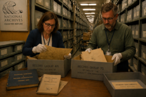 Third, the National Archives does not contain name origin documentation. To confirm this absence, Cabin in the Pines engaged two professional researchers to conduct onsite archival work at the National Archives in College Park, Maryland.(22) Their task was to examine NARA record groups and finding aids, review primary documents and maps, and search for evidence of the name’s origin. To ensure independent verification and reduce interpretive bias, each researcher submitted separate reports. Both were unable to find any decision notes connecting the name to Roosevelt. This supports the conclusion that the name preexisted official maps, consistent with oral tradition.
Fourth, U.S. Forest Service, Pike-San Isabel National Forests & Cimarron and Comanche National Grasslands, San Carlos Ranger District also confirmed their maps do not contain any information related to name origin.(23)
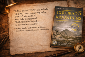 Fifth, there is online evidence suggesting that hikers, ranchers, and hunters in the area have relied on community memory, inherited storytelling, and unverified narratives that associate the peak with Theodore Roosevelt. For example, Randy Jacobs and Robert M. Ormes’s Guide to Colorado Mountains, Tenth Edition, includes a note on Teddys Peak stating, “Teddy Roosevelt hunted in the Trinchera country.”(24)
Sixth, the controversy surrounding Roosevelt’s midnight forest proclamations likely heightened his visibility among those living in and around what became the Las Animas National Forest. Because Roosevelt’s proclamations directly affected land use and were both supported and opposed, they became a subject of local discussion. In this context, Roosevelt’s name would have been closely associated with the newly defined landscape, creating a plausible pathway by which a prominent feature could acquire its name through local usage, consistent with oral tradition.
 Lastly, regional heritage frameworks recognize that cultural landscapes are often interpreted through shared memory and tradition, particularly in areas on both sides of the Sangre de Cristo Mountains.(25)
This question extends beyond the origin of a single place name. It reflects how landscapes acquire meaning through memory, usage, and shared experience, even when formal records remain silent. In such cases, names become a form of historical inheritance, carried forward not by documentation, but by shared understanding.
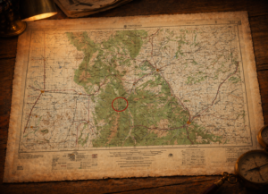
The logic of linked lands. Teddys Peak rises from the Sangre de Cristo Range within the boundaries of the San Isabel National Forest. That forest was established during Theodore Roosevelt’s sweeping conservation expansions, when millions of acres were set aside under presidential authority.
The San Isabel National Forest did not emerge from a single, fixed moment of designation. Rather, it was shaped through a series of presidential proclamations between 1902 and 1907, as federal forest policy evolved from initial reservation to active expansion and consolidation under Theodore Roosevelt and his chief forester, Gifford Pinchot.(26)
The map below illustrates the expansion of the San Isabel Forest Reserve between 1902 and 1910, as discussed in greater detail later. The boundaries shown are interpretive approximations derived from township and range coordinates described in federal proclamations. Original maps from this period are rare, often hand-drawn, and not always consistent with modern cartographic standards. While not precise surveys, these reconstructions accurately depict the forest’s expansion and the point at which Teddys Peak became incorporated within its boundaries.
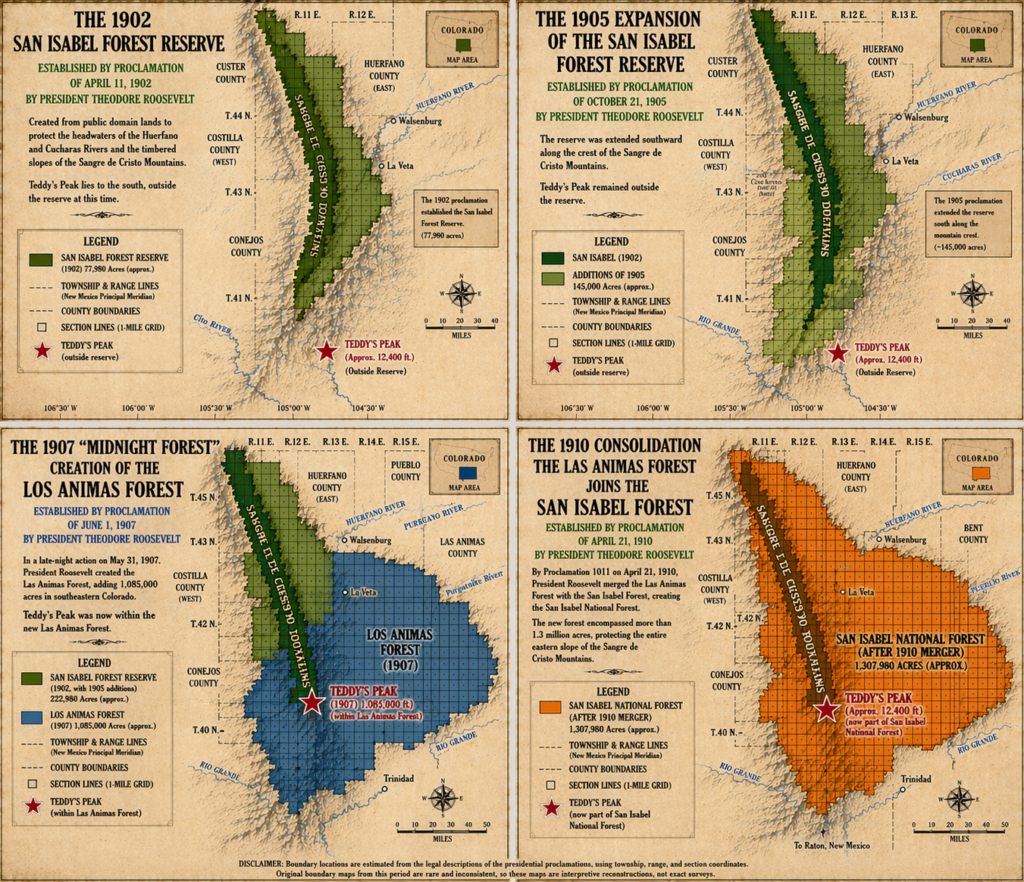
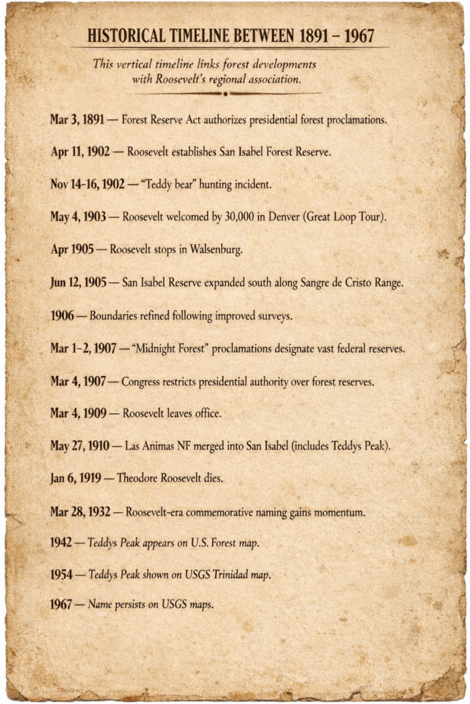
The process began on April 11, 1902, when Roosevelt established the San Isabel Forest Reserve by presidential proclamation, setting aside a substantial portion of southern Colorado under federal protection.(27) At that time, however, the reserve was smaller and focused on the Eureka Mountain area and the Upper Arkansas watershed, more than fifty-five miles north of what is now called Teddys Peak, and it did not yet include the southern Sangre de Cristo range as it does today.(28)
This initial act, however, did not define the reserve in final form. In the years that followed, additional Presidential Proclamations by Roosevelt in 1905 and 1906 adjusted and expanded forest boundaries even more.(29) These incremental changes reflect the experimental and adaptive nature of early conservation policy, in which reserves were actively shaped rather than statically defined.
The most consequential phase came in early March 1907, during what later became known as the “Midnight Forest” proclamations. Facing imminent congressional action to revoke presidential authority to create or expand forest reserves, Roosevelt directed Pinchot and Forest Service officials to moved urgently and prepare a final series of designations before he would be forced to sign the legislation on March 4, 1907.(30) Over the course of March 1–2, 1907, Roosevelt signed numerous proclamations establishing new reserves and expanding existing ones just hours before the restriction on his authority took effect.(31) Among these was the creation of the Las Animas National Forest on March 1, 1907.(32)
 This detail is particularly significant for understanding the historical setting of Teddys Peak. At the time of these final proclamations, the peak would have fallen within the newly established Las Animas National Forest, placing it directly within the scope of Roosevelt’s last-minute conservation actions.(33) The association is not merely geographic but chronological, linking the landscape to a highly visible and widely debated moment in federal land policy. Roosevelt’s strategically timed midnight proclamations were polarizing, widely supported by conservationists yet strongly opposed by local lumber, mining, and railroad interests that held significant influence in Washington. The effort to restrict Roosevelt’s authority was led by Senator Charles William Fulton and supported by a broader bloc of western lawmakers representing states including Oregon, Washington, Idaho, Montana, Colorado, and Wyoming, many of whom were aligned with grazing, logging, mining, and homesteading interests.(34)
The controversy surrounding the 1907 proclamations made Roosevelt’s name highly visible in the region, embedding it in local conversation and association with the landscape.
The administrative structure continued to evolve in the years that followed. On May 27, 1910, the Las Animas National Forest was combined with the San Isabel National Forest, consolidating management of the region under a single administrative unit.(35) By that point, the boundaries and identity of the forest had been shaped by nearly a decade of presidential action, reflecting both deliberate planning and urgent, strategic execution.
Considered together, these actions demonstrate that the San Isabel was not the product of a single proclamation, but of a sequence of decisions made over time, initially established, repeatedly adjusted, and ultimately expanded under the pressure of political constraint. This layered history helps explain how prominent national figures and events became associated with specific landscapes, even in the absence of a single formal naming record.
Public recognition and cultural association. Theodore Roosevelt’s popularity in Colorado, his broader cultural recognition, and the widespread use of his name in public landscapes together make ‘Teddys Peak’ a plausible informal tribute.
 Roosevelt’s recognition in Colorado was not incidental but cultivated through direct engagement with the region, most notably during his Great Loop Tour of 1903.(36) Contemporary accounts describe thirty thousand people gathering at the Colorado Capitol in Denver to greet him.(37) While in Boulder members of the crowd reportedly lifted him onto their shoulders and carried him to his car.(38) His itinerary also brought him through southern Colorado communities including Pueblo, Trinidad, Canon City, and later Walsenburg, reinforcing his visibility in the same broad region as present-day Teddys Peak.(39, 40). In addition to his public visibility, Roosevelt was widely admired by Forest Service personnel and conservationists across Colorado. One Forest Service historical document notes that in 1932 the Colorado National Forest was renamed to honor President Theodore Roosevelt, described as “the person who was the most responsible for its creation.”(41)
By the early twentieth century, “Teddy” was already widely understood as shorthand for Theodore Roosevelt.(42) His public image had become closely associated with wilderness, conservation, hunting, and rugged life. The widely publicized 1902 bear-hunting episode, later tied to the origin of the teddy bear, helped cement that nickname in national culture, while cartoons and popular media reinforced Roosevelt’s frontier persona.(43) In that setting, a mountain called “Teddys Peak” would have carried an obvious cultural association for many Americans, especially in a forested landscape shaped by Roosevelt-era conservation.
 The name also fits a broader pattern of public commemoration. Roosevelt’s name appeared across American landscapes in the decades following his presidency and death, including Roosevelt National Forest in Colorado and Theodore Roosevelt National Memorial Park, later Theodore Roosevelt National Park, in North Dakota.(44, 45, and 46) More broadly, Colorado has a well-documented tradition of naming places for presidents and nationally recognized public figures.(47)
Within that context, the emergence of Teddys Peak on mid-twentieth-century Colorado maps is both consistent with established naming patterns and historically plausible.
The Weight of Evidence
The association between Teddys Peak and Theodore Roosevelt does not rest on a single document or formal naming record. Instead, it emerges from a convergence of evidence.
 No archival record links the name to a formal decision by the U.S. Board on Geographic Names. Mapping records confirm the name was in use by the mid-twentieth century, adopted without a name origin explanation in official maps.
At the same time, the historical context is difficult to ignore. Theodore Roosevelt’s conservation policies directly shaped the San Isabel National Forest in which the peak stands. His popularity in Colorado was well documented, and his name became closely associated with wilderness, conservation, and outdoor life. Cultural references, guidebooks, and local accounts have long linked the peak to Roosevelt, reflecting a persistent thread of regional memory.
The evidence points not to a formal act of naming, but to a name that likely emerged through common use, consistent with oral tradition. In that setting, “Teddys Peak” most plausibly reflects an informal honorific, shaped by the legacy of Theodore Roosevelt in local forests, and sustained through oral tradition.
Absolute certainty may remain out of reach. Yet the balance of historical context, naming patterns, and cultural association makes the connection both reasonable and compelling.
And still, the mountain itself stands apart from the question. Long before its name was recorded, it rose above the valley. Long after the debate is settled, it will remain.(48)
Companion Interview
Watch a short conversation as Gene Roncone, curator of the Cabin in the Pines blog, sits down with local historian and outdoor enthusiast Bruce Johnson to explore why this story still matters in the Cuchara Valley today.
Footnotes
Parenthetical numbers in the text (e.g., 5) correspond to the sequentially numbered citations listed below.
1. The coordinates place it at approximately 37.3408 degrees N, 105.1658 degrees W, on the Trinchera Peak 7.5-minute quadrangle. “Teddys Peak,” TopoZone, accessed February 19, 2026, https://www.topozone.com/colorado/costilla-co/summit/teddys-peak/
2. “Teddys Peak, Colorado,” Peakbagger.com, accessed February 20, 2026, https://www.peakbagger.com/peak.aspx?pid=56873.
3. U.S. Geological Survey, Geographic Names Information System (GNIS): “Teddys Peak,” Feature ID 192934, accessed March 26, 2026, https://edits.nationalmap.gov/apps/gaz-domestic/public/gaz-record/192934
4. Theodore Roosevelt, “Proclamation 467—Establishing the San Isabel Forest Reserve,” April 11, 1902, The American Presidency Project, https://www.presidency.ucsb.edu/documents/proclamation-467-establishing-the-san-isabel-forest-reserve
5. U.S. Forest Service, The Early Forest Service Organization Era, 1905–1910, in History of the Forest Service, accessed April 6, 2026, https://npshistory.com/publications/usfs/fs-650/sec2.htm#:~:text=%22Midnight%20Reserves.%22
6. United States. President (William H. Taft). “Proclamation 1040: San Isabel National Forest, Colorado.” 27 May 1910. In Statutes at Large, vol. 36, p. 2701. https://www.govinfo.gov/content/pkg/STATUTE-36/pdf/STATUTE-36-Pg2701.pdf. The proclamation and its associated map can be downloaded at https://cabininthepines.org/J90_1910__Proclomation&Map.pdf.
7. Forest Reserve Act,” Encyclopedia Britannica, last modified May 6, 2025, https://www.britannica.com/topic/Forest-Reserve-Act. The Forest Reserve Act of 1891 (General Revision Act) granted the president authority to set aside public lands as forest reserves, forming the legal foundation for the conservation policies later expanded under Theodore Roosevelt’s administration; see the General Land Reform Act (1891),” in Encyclopedia of the Politics of the American West, ed. Steven L. Danver (Thousand Oaks, CA: CQ Press, 2013), accessed April 4, 2026, https://sk.sagepub.com/ency/edvol/encyclopedia-of-politics-of-the-american-west/chpt/general-land-reform-act-1891.
8. Arvid D. Blecha, Colorado Place Names: A Genealogical and Historical Guide, unpublished manuscript, Western History and Genealogy Department, Denver Public Library, consulted March 2026. https://history.denverlibrary.org/sites/history/files/Place_Names_of_Colorado.pdf
9. George R. Stewart, Names on the Land: A Historical Account of Place-Naming in the United States (New York: Random House, 1945); Arvid D. Blecha, Colorado Place Names: A Genealogical and Historical Guide (Denver Public Library, Western History Collection); U.S. Board on Geographic Names, “Principles, Policies, and Procedures.”
10. Many of the most recognizable and iconic place names began as informal, descriptive, or colloquial terms and were only later standardized by mapmakers, surveyors, or the U.S. Board on Geographic Names. They arose from everyday local use and were later formalized on maps, as seen with Death Valley, Denali, Devils Tower, Grand Teton, Great Salt Lake, Longs Peak, Pikes Peak, The Grad Canyon, and Yellowstone. Also see George R. Stewart, Names on the Land: A Historical Account of Place-Naming in the United States, rev. and expanded ed. (New York: New York Review Books, 2008)
11. 1942 San Isabel National Forest map at https://cabininthepines.org/J90_1942_San_Isabel_Mapb.pdf, and Western United States: Trinidad Quadrangle, 1:250,000, ed. 1 (U.S. Geological Survey, Army Map Service, 1954), map image, accessed February 19, 2026, https://ngmdb.usgs.gov/ht-bin/tv_browse.pl?id=1c563c0fdc01d7993bed36ecc688bb32, showing the first recorded designation of “Teddys Peak” in Colorado.
12. U.S. Geological Survey, Topographic Instructions of the United States Geological Survey (Washington, DC: U.S. Government Printing Office, 1958), 3–5; U.S. Army Map Service, “Army Map Service: Its Mission and Products,” Department of the Army, c. 1950s.
13. What is the Geographic Names Information System (GNIS)?, U.S. Geological Survey, U.S. Board on Geographic Names, accessed February 20, 2026, https://www.usgs.gov/us-board-on-geographic-names/what-geographic-names-information-system-gnis#:~:text=12.%20Is%20the%20possessive%20apostrophe%20%22s%22%2C%20such%20as%20in%20Pike’s%20Peak%2C%20allowed%20in%20the%20GNIS?%C2%A0
14. “Theodore Roosevelt,” Theodore Roosevelt,” Encyclopedia Britannica, last modified March 22, 2026, https://www.britannica.com/biography/Theodore-Roosevelt. showing Roosevelt’s birth on October 27, 1858, and his death on January 6, 1919.
15. GNIS, Feature ID 192934, https://edits.nationalmap.gov/apps/gaz-domestic/public/gaz-record/192934.
16. U.S. Board on Geographic Names, “Domestic Names,” U.S. Geological Survey, accessed March 30, 2026, https://www.usgs.gov/us-board-on-geographic-names/domestic-names.
17. Peter L. Stark, The Mapping of Our National Forests (2014), pg. 1. accessed via the National Museum of Forest Service History, https://forestservicemuseum.org/wp-content/uploads/2022/06/Mapping-the-National-Forests_updated-June2022.pdf. See discussion linking administrative history and cartography in documenting changes in forest boundaries, names, and landscape features.
18. U.S. Geological Survey, National Map Help Desk, email to Gene and Rhonda Roncone, March 30, 2026, regarding “Teddys Peak” (Feature ID 192934), including attached field edit notes, “Names & Information” oversheet (October 1967), and Trinchera Peak quadrangle source documentation. This email confirms the significant likelihood that Teddys Peak (Feature ID 192934) was added to cartography based on historic oral traditions as opposed to BGN application or vetting. This confirms the following:
• The name “Teddys Peak” was already in use by at least 1967, appearing on the Trinchera Peak quadrangle map.
• The feature was compiled from multiple sources, including field information overlays, AMS Trinidad maps, and San Isabel National Forest data.
• There is no record of review or decision by the U.S. Board on Geographic Names (BGN).
• Supporting materials, including field edit notes and a 1967 “Names & Information” oversheet, confirm the name’s usage but provide no explanation of its origin or meaning.
The documents corroborate these findings by showing the name in official mapping materials without any associated naming justification.
19. San Isabel National Forest Map, 1942, PDF, https://cabininthepines.org/J90_1942_San_Isabel_Mapb.pdf (accessed April 16, 2026).
20. The 1942 San Isabel National Forest map at https://cabininthepines.org/J90_1942_San_Isabel_Mapb.pdf, the 1954 Army Corps of Engineers map at https://ngmdb.usgs.gov/ht-bin/tv_browse.pl?id=1c563c0fdc01d7993bed36ecc688bb32, and the 1967 Trinchera Peak map at http://www.cabininthepines.org/1968_Trinchera_TeddysPeak_Map_.pdf
21. Matthew O’Donnell, Office of the Executive Secretary, Domestic Names Committee, U.S. Board on Geographic Names, email message to author, March 30, 2026, stating that no records exist indicating that “Teddys Peak” was proposed to, reviewed by, or voted on by the Board, and that most names appearing in GNIS were adopted from U.S. Geological Survey maps without formal Board action.
22. Mary Rodgers and Kevin Morrow, independent archival research reports examining NARA record groups, finding aids, and primary documents related to the name origin of “Teddys Peak”, onsite research conducted at the National Archives and Records Administration, College Park, Maryland, commissioned by Cabin in the Pines, 2026.
23. Destiny Chapman (district ranger, U.S. Forest Service, Pike-San Isabel National Forests & Cimarron and Comanche National Grasslands, San Carlos Ranger District), email message to Gene and Rhonda Roncone, April 2, 2026, reporting no identified records regarding the origin of the name “Teddys Peak” in Forest Service files.
24. Randy Jacobs and Robert M. Ormes, Guide to the Colorado Mountains, 10th ed. (Golden, CO: Colorado Mountain Club Press, 2020), 130: “Teddys Peak (12,575′) is a climb of 2,100′, either by ridge or by valley, from 0.5 mile north of the Bear Lake Campground. Teddy Roosevelt hunted in the Trinchera country.” https://www.google.com/books/edition/Guide_to_the_Colorado_Mountains/RqIJGW5OoaIC?hl=en&gbpv=1&dq=%22teddys+peak%22+colorado&pg=PA129
25. Sangre de Cristo National Heritage Area, Management Plan, February 2013, Appendix B, “Culture & Community,” B-27, https://www.sangreheritage.org/wp-content/uploads/2019/06/Plan-with-Apendix-low-res.pdf?utm
26. Theodore Roosevelt’s last-minute proclamations of March 1907, often called the “midnight forests,” added roughly 16 million acres of national forest just before Congress closed further withdrawals in several Western states, marking the climax of the political backlash against his forest-reserve program. See “Midnight Forest Conservation,” Midnight Forest Conservation, accessed, https://midnightforest.com/midnight-forest-conservation/. For San Isabel’s place within this program, including its establishment on April 11, 1902 (32 Stat. 1988) and enlargement on June 12, 1905 (34 Stat. 3083), see Forest History Society, “San Isabel Forest Reserve & National Forest, Colorado, 1902–Present,” National Forest Service Library, accessed, https://nfsl.contentdm.oclc.org/digital/api/collection/p17053coll4/id/1307/download
27. Theodore Roosevelt, “Proclamation 467—Establishing the San Isabel Forest Reserve, Colorado,” April 11, 1902, in Messages and Papers of the Presidents, and U.S. Forest Service historical records, https://www.fs.usda.gov. Both the proclamation and its associated map can be accessed at https://cabininthepines.org/J90_1902_Proclomation&Map.pdf
28. U.S. Forest Service, San Isabel Forest Reserve and National Forest, Colorado: Administrative History, National Forest System records, noting that the original April 11, 1902 proclamation established approximately 77,980 acres centered on Eureka Mountain, and that the June 12, 1905 proclamation expanded the reserve to 321,227 acres, extending “along the entire Sangre de Cristo Range from Salida south to the Sangre de Cristo Grant”. The 1902 proclamation and its associated map can be accessed at https://cabininthepines.org/J90_1902_Proclomation&Map.pdf. The 1905 proclamation and map can be downloaded at https://cabininthepines.org/J90_1905__Proclomation&Map.pdf.
29. U.S. Forest Service, Land Areas of the National Forest System, historical summary tables and early proclamation records, https://www.fs.usda.gov; see also Harold K. Steen, The U.S. Forest Service: A History (Seattle: University of Washington Press, 1976).
30. U.S. Forest Service, The Early Forest Service Organization Era, 1905–1910, in History of the Forest Service, accessed April 6, 2026, https://npshistory.com/publications/usfs/fs-650/sec2.htm#:~:text=%22Midnight%20Reserves.%22
31. Gifford Pinchot, Breaking New Ground (New York: Harcourt, Brace and Company, 1947), 228–230; see also Char Miller, ed., The Greatest Good: A Forest Service Centennial Anthology (Durham, NC: Duke University Press, 2005).
32. Theodore Roosevelt, “Proclamation Establishing the Las Animas Forest Reserve,” March 1, 1907, Theodore Roosevelt Digital Library, Theodore Roosevelt Center, Dickinson State University, https://www.theodorerooseveltcenter.org/digital-library
33. Destiny Chapman, District Ranger, Pike-San Isabel National Forests & Cimarron and Comanche National Grasslands, email to Gene Roncone, April 3, 2026, stating that Teddys Peak lay within the Las Animas National Forest (created March 1, 1907, as part of Theodore Roosevelt’s “midnight forests”) and was incorporated into the San Isabel National Forest on May 27, 1910.
34. Doris Kearns Goodwin, The Bully Pulpit: Theodore Roosevelt, William Howard Taft, and the Golden Age of Journalism (New York: Simon & Schuster, 2013), excerpted in Library of Congress, “Common Section,” accessed April 16, 2026. https://erenow.org/common/bullypulpit/21.php#:~:text=conservation%20measures.%20On-,February%2025%2C%201907,-%2C%20the%20Senate%20passed
35. U.S. Forest Service, “National Forests of the United States,” administrative history tables; see also Federal Register historical compilations of forest consolidations, May 27, 1910. The proclamation and associated map can be accessed at https://cabininthepines.org/J90_1910__Proclomation&Map.pdf.
36. Michael F. Blake, Go West, Mr. President: Theodore Roosevelt’s Great Loop Tour of 1903 (Boulder: TwoDot Books, 2002).
37. Agnes Wright Spring, “Theodore Roosevelt in Colorado,” The Colorado Magazine 35, no. 4 (October 1958): pg. 243, accessed via PDF, https://www.historycolorado.org/sites/default/files/media/document/2018/ColoradoMagazine_v35n4_October1958.pdf
38. Agnes Wright Spring, “Theodore Roosevelt in Colorado,” The Colorado Magazine 35, no. 4 (October 1958): 245, accessed via PDF, https://www.historycolorado.org/sites/default/files/media/document/2018/ColoradoMagazine_v35n4_October1958.pdf
39. Theodore Roosevelt, remarks in Denver, Colorado Springs, Pueblo, and Trinidad, Colorado, April 1903, in Michael F. Blake, Go West, Mr. President: Theodore Roosevelt’s Great Loop Tour of 1903 (Boulder: TwoDot Books, 2002).
40. “Huerfano County News of the Day, 1905 April, Walsenburg,” Huerfano County News (compilation of local newspaper items), accessed March 26, 2026, https://www.kmitch.com/Huerfano/news1900.html#:~:text=President%20Roosevelt’s
41. U.S. Forest Service, 2006 Monitoring Report: Arapaho, Roosevelt, Pawnee (no appendices) (Washington, DC: U.S. Department of Agriculture, Forest Service, 2006), 6, accessed February 19, 2026, https://www.fs.usda.gov/sites/nfs/files/legacy-media/arp/2006%20Monitoring%20Report%20no%20appendices.pdf
42. Seth Boster, “Was the Teddy Bear Born in Colorado?” The Denver Gazette, November 8, 2020, https://www.denvergazette.com/2020/11/09/was-the-teddy-bear-born-in-colorado-e5ddcad3-370e-52ba-ab5f-c7321a077f2a/
43. National Park Service, “The Story of the Teddy Bear,” Theodore Roosevelt Birthplace National Historic Site, U.S. National Park Service, accessed February 19, 2026, https://www.nps.gov/thrb/learn/historyculture/storyofteddybear.htm; Theodore Roosevelt Association, “Real Teddy Bear Story,” accessed February 19, 2026, https://theodoreroosevelt.org/content.aspx?page_id=22&club_id=991271&module_id=333084
44. Michael P. Cullinane (public historian, Theodore Roosevelt Association), email message to Gene and Rhonda Roncone, March 23, 2026, discussing Theodore Roosevelt’s 1903 Great Loop tour and geographic features bearing his name. There are several land/water features that use Roosevelt’s name including:
Roosevelt Lake (AZ) made by Roosevelt Dam, Mount Roosevelt (SD) commemorated by the Friendship Tower,
Mount Roosevelt (VT) commemorated by the state, which has honored several presidents in the same range,
Rio Roosevelt (Brazil) formerly River of Doubt that he navigated, Roosevelt Range (Greenland) named by Robert Peary who was supported by the president.
45. National Park Service, “Park History,” Theodore Roosevelt National Park, U.S. Department of the Interior, accessed April 4, 2026, https://www.nps.gov/thro/learn/historyculture/park-history.htm.
46. Roosevelt National Forest was originally established as part of the Medicine Bow Forest Reserve and later renamed the Colorado National Forest; it was renamed Roosevelt National Forest in 1932 in honor of President Theodore Roosevelt. See Discover History,” Arapaho & Roosevelt National Forests, Pawnee National Grassland, U.S. Forest Service, accessed April 4, 2026, https://www.fs.usda.gov/r02/arp/recreation/discover-history. Also see https://uscode.house.gov/view.xhtml?edition=prelim&num=0&req=granuleid%3AUSC-prelim-title16-section241g
47. Colorado has a surprisingly rich landscape of place names tied to U.S. presidents and major conservation figures, especially those connected to western expansion, exploration, and early conservation policy. Examples would include Roosevelt National Forest, Roosevelt Tunnel, Mount Lincoln, Lincoln Park, Mount Washington, Washington Peak, Mount Jefferson, Jefferson County, Mount Buchanan, Mount Muir, Pikes Peak, and others.
48. Author’s note: In preparing this article, the author used AI-assisted tools for research support, proofreading, fact-checking, and stylistic refinement. All narrative choices, analysis, and historical interpretations are the author’s own, and responsibility for accuracy rests solely with the author. The blog’s research methodology statement is available at https://cabininthepinescuchara.blogspot.com/2019/03/methodology-sources-and-use-of-research.html